Title:
Development of a UAS-based Sensing Approach to Detect and Measure Pavement Frost Heaves
Poster
Preview Converted Images may contain errors
Abstract
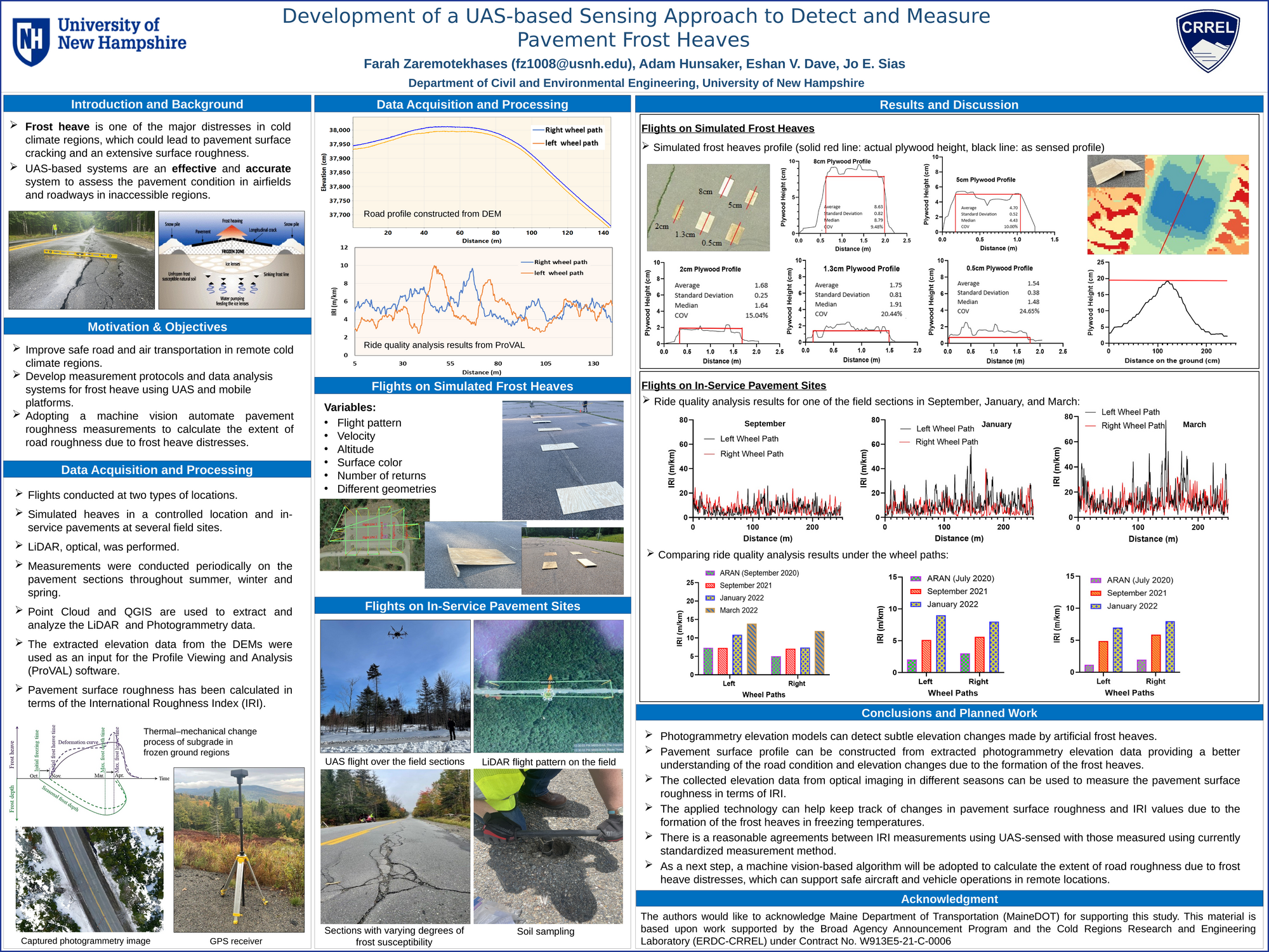
The combination of low temperatures, precipitation, and high-water table causes the formation of subsurface frost in pavements leading to the formation of frost heaves. Specifically, asphalt pavements in remote cold climate regions face extreme conditions, which degrade the performance of the asphalt pavement roads and cause extensive damage to their structural capacity. Road pavement damage from frost heave could result in pavement surface cracking and lead to an extensive surface roughness which hinders driving safety and vehicular operation. The use of UAS-based systems has become a popular approach to assess pavement conditions and measure pavement surface profiles due to their advantages of efficiency and accuracy, especially for road and airport infrastructures located in remote and difficult-to-access areas. The primary objective of this research is to determine the efficiency and accuracy of the UAS-based sensing systems such as photogrammetry and LiDAR to access the pavement condition and measure the extent of pavement frost heaves. The sensors are mounted on an Unmanned Aircraft System (UAS) capable of providing measurements over large spatial domains in a single flight and are well suited for difficult-to-access regions. Moreover, it can be used to develop an automated sensing and decision system to support safe aircraft and vehicle operations in remote cold-climate areas. Experiments have been conducted on simulated heaves as well as actual cold climate pavement sections representing varying degrees of frost susceptibility and pavement conditions. Five sets of photogrammetry and LiDAR flights were performed on simulated frost heaves. Simulated frost heaves with well-defined geometric features (constant slopes and stepped elevation changes) were fabricated to evaluate the ability of UAS sensors to detect and accurately reconstruct subtle elevation changes and irregularities on a pavement surface. Moreover, several parameters affecting the resolution of the UAS observations, such as the system's speed, flight lines, altitude, and existing overlap in the dataset, have been examined. The flights on the in-service pavement sites were conducted on four pavement sections with varying degrees of frost susceptibility located in the north-eastern United States. The flights were conducted at various times during the year to capture baseline conditions as well as varying frost heave severity. The finding from this study provides suitable UAS flight parameters for conducting frost heave measurements. The pavement surface profile has been constructed from extracted photogrammetry and LiDAR elevation data collected in four different seasons. Pavement surface roughness has been measured in terms of the International Roughness Index (IRI), and variation between measured IRI values has been evaluated during different seasons due to the formation of the frost heave distress. The key outcomes of this work demonstrate that UAS-based sensing systems such as photogrammetry and LiDAR can reliably detect pavement frost heaves and provide high confidence in the future development of an automated system to measure pavement roughness due to frost heave distresses.
Authors
| First Name |
Last Name |
|
Jo
|
Sias
|
|
Eshan
|
Dave
|
|
Adam
|
Hunsaker
|
|
Farah
|
Zaremotekhases
|
Leave a comment
Submission Details
Conference GRC
Event Graduate Research Conference
Department Civil and Environmental Engineering (GRC)
Added April 10, 2023, 5:20 p.m.
Updated April 10, 2023, 5:21 p.m.
See More Department Presentations Here