Title:
SMAP-Informed Forecasting of Earthquake-Induced Landslides
Poster
Preview Converted Images may contain errors
Abstract
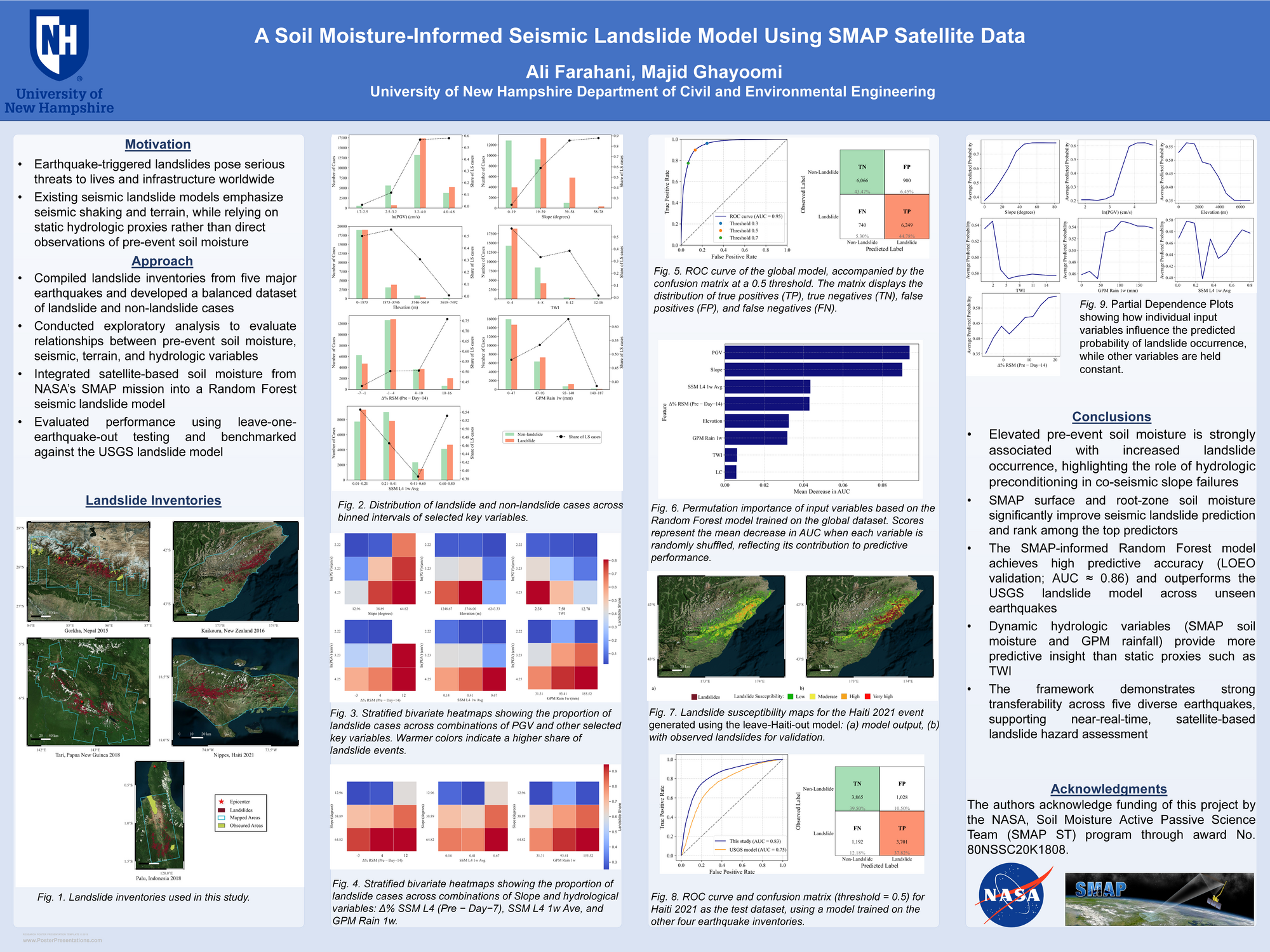
Earthquake-triggered landslides are a leading cause of seismic disaster-related fatalities and infrastructure damage. While forecasting models have advanced significantly in capturing terrain and seismic drivers, most continue to treat hydrologic conditions as static or rely on static proxies like historical precipitation or topographic indices. This limits their ability to account for the dynamic, event-specific soil saturation conditions that critically influence slope stability at the time of shaking. This study presents a global seismic landslide susceptibility model that integrates near-real-time soil moisture observations from NASA’s Soil Moisture Active Passive (SMAP) satellite mission. By incorporating both surface and root-zone soil moisture, the model captures key hydrologic precursors to slope failure. A comprehensive landslide and non-landslide database was constructed using high-resolution remote sensing inventories from five major earthquakes—Nepal (2015), New Zealand (2016), Papua New Guinea (2018), Indonesia (2018), and Haiti (2021). These were combined with seismic intensity, topographic, and hydrologic variables, including SMAP and Global Precipitation Measurement (GPM) data. Following exploratory analysis of variable relationships and interaction analysis of input features, a random forest classifier was trained using the integrated dataset, and its performance was assessed through evaluation metrics, sensitivity and reliability analysis. Soil moisture features—particularly the 1-week average surface moisture prior to the event and the percent change in root-zone moisture between the event day and 14 days prior—capturing short-term soil wetting trends—ranked among the most influential predictors. The model achieved an average AUC of 0.86 across blind tests, where each earthquake was excluded from training and used solely for validation—demonstrating improved performance over the USGS global landslide model lacking hydrologic inputs. The framework highlights how antecedent and evolving hydrologic conditions modulate seismic landslide occurrence and emphasizes the operational potential of satellite-based earth observations for assessing earthquake impacts.
Authors
| First Name |
Last Name |
|
Majid
|
Ghayoomi
|
|
Ali
|
Farahani
|
Leave a comment
Submission Details
Conference GRC
Event Graduate Research Conference
Department Civil and Environmental Engineering (GRC)
Group Strengthening UNH's Impact
Added April 14, 2026, 1:44 p.m.
Updated April 14, 2026, 1:44 p.m.
See More Department Presentations Here