Title:
Assessing Topographic Mapping Accuracy using Aerial Drone with Terrestrial and Submerged Aquatic Ground Control Points
Poster
Preview Converted Images may contain errors
Award:
Winner
Abstract
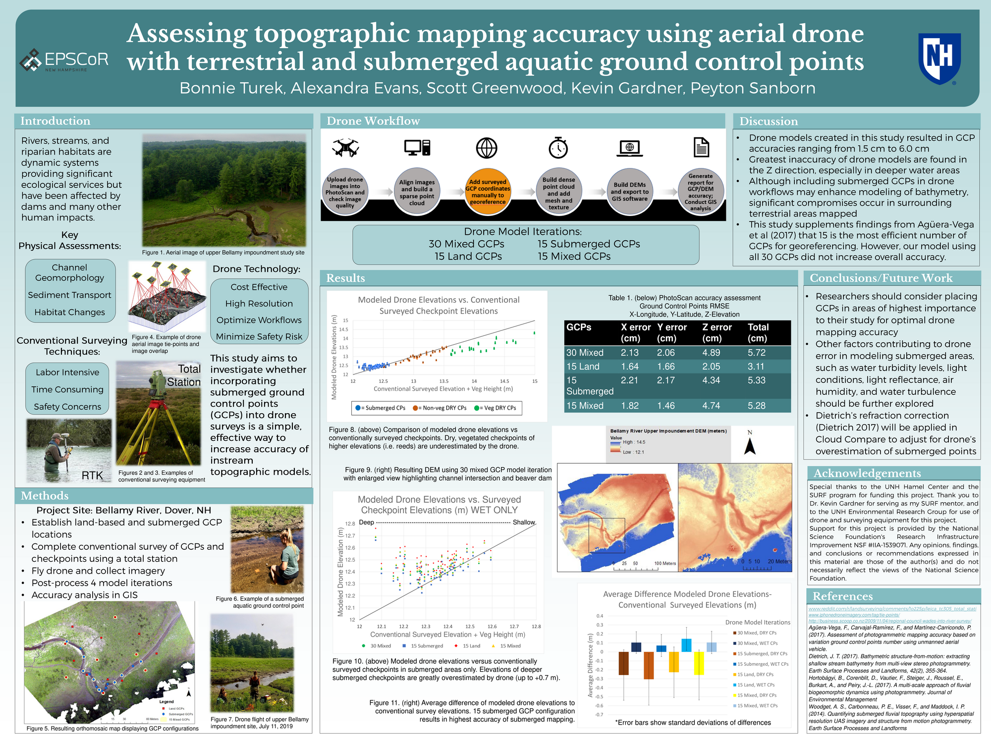
Inspired by the influence of drone applications in scientific research, my SURF study aims to improve the accuracy of riverine topographic modeling by testing the use of terrestrial and submerged aquatic ground control points (GCPs) in drone surveys of the Bellamy River Reservoir. Accurate mapping of river-scapes is critical to investigations of before-and-after management activities, such as dam removals, and better understanding topographic features created by physical, chemical, and biological processes in rivers and watersheds. These studies build on our increasing understanding and quantification of the cycling of chemical and biological substances in rivers and the valuable ecological services that watersheds provide. The evolution of remote sensing, drone technology, and digital elevation models (DEMs) provide an alternative to conventional, labor-intensive ground survey measurements and are of increasing importance for creating topographic products valuable to studies of river-scapes and watershed processes. Land-based GCPs are routinely used to develop highly accurate models, however, in rivers we seek to accurately measure submerged topography, which has only been done in limited environments due to numerous technical challenges. Incorporating submerged GCPs into drone workflows may be a simple, yet effective way to improve instream topography models. Results of this study are expected to contribute key information for restoration planning for rivers and other aquatic habitats, studies of land use and impacts of human infrastructure, especially dams, in the hopes of creating and maintaining a more sustainable relationship with our natural environment.
Authors
| First Name |
Last Name |
|
Bonnie
|
Turek
|
Leave a comment
Submission Details
Conference URC
Event Interdisciplinary Science and Engineering (ISE)
Department Earth Sciences (ISE)
Added April 15, 2020, 8:11 p.m.
Updated April 15, 2020, 8:11 p.m.
See More Department Presentations Here